Reforming Visual Resource Management in the Desert
America's southwestern deserts are home to some grand vistas where we can enjoy the serenity of a place mostly undisturbed by human development, and it is our obligation to protect the relatively intact landscapes that remain for the enjoyment of future generations. However, our land management practices offer only fragmented and incomplete protection to these visual resources - pockets of mountain wilderness surrounded by unprotected valleys. The result is that destructive projects can be permitted in remote areas that destroy not only the land on which they are built, but also spoil an otherwise intact vista of mountains and valleys that seem to stretch beyond the horizon, all in Mother Nature's domain. We will need careful consideration of these visual resources in California's Desert Renewable Energy Conservation Plan (DRECP), and vocal community support for legislation such as the California Desert Protection Act and other conservation bills. But from a more systematic perspective, the Bureau of Land Management should reconsider how it evaluates these resources across the desert southwest when it revises regional management plans.
If a hike in the Hollywood Hills is the equivalent of taking a Vitamin N pill, a day in the open desert can be the equivalent of a month at a natural rehab center. When I go camping and hiking in the desert I look for places in the where desert basins and ranges stretch beyond the horizon. The vistas that envelop me during the day are as striking and inspiring as the blanket of stars that appear at night, and I plan my recreation around these opportunities. This resource has eroded significantly over recent decades, and if you study plans for major industrial developments in the desert you will realize that these visual resources - vast and largely untouched landscapes - are going to continue to disappear.
Grading the Desert's Beauty
Figuring out how to save this resource requires understanding of how it is currently managed. Much of the desert beyond and between our cities in the southwest is managed by various agencies - the Bureau of Land Management, Fish and Wildlife Service, National Park Service, the U.S. Forest Service, and the Department of Defense. We will focus on the Bureau of Land Management (BLM) because visual resources in the desert are impacted the most by the BLM permitting of various projects, including transmission lines, pipelines, solar, wind, and transportation projects.
The way you and I might grade the beauty of the desert is much different than how the BLM evaluates this resource under Visual Resource Management plans. Public lands are graded based on a number of factors to determine overall scenic quality with grades of A, B, or C, according to the BLM's Visual Resources handbook. The BLM considers the following factors when evaluating the beauty of a desert landscape, which can earn 0-5 points under each factor, with more points awarded to more favorable features, and less points to less desired or spectacular features. The BLM adds up the points after evaluating each factor. A total of 19 or more points gives the landscape a Scenic Quality rating of "A," 12 to 18 points will earn the landscape a rating of "B," and 11 or less points is a "C" rating. The factors considered and how they are evaluated seem to produce ratings that are biased against the ecosystems of our basin and range deserts.
Factors considered when determining the Scenic Quality rating of public lands:
Landform: Five points for "[h]igh vertical relief as expressed in prominent cliffs, spires, or massive rock outcrops, or severe surface variation or highly eroded formations including major badlands or dune systems; or detail features dominant and exceptionally striking and intriguing such as glaciers." Only one point if the landscape consists of "[l]ow rolling hills, foothills, or flat valley bottoms; or few or no interesting landscape features. " Most of the Mojave Desert includes some impressive ranges, but perhaps not as severe in appearance to earn five points, based on how I read this rating. The subtle alluvial fans and bajadas around and between these desert mountains, and the flat playas are not appreciated by the criteria in the landform factor.
Vegetation: A rain forest would get five points, but the desert may be at a disadvantage. Although this factor does evaluate seasonal wildflower displays and "intriguing" plant life such as "gnarled or windbeaten trees, and Joshua trees," some of my favorite landscapes are dominated by creosote bushes and other shrubs that may not strike a BLM evaluator as presenting the "variety of patterns, forms, and textures" that earn higher marks. How much the BLM values perennial displays is not clear, and it is also not clear if the seasonal appearance of perennial plants at a level less than a "spectacular" display is considered.
Water: Let's face it, the desert doesn't have much water, and I highly doubt the BLM will give the desert any credit for its hidden springs and dry washes that only come to life during rare storms. And where there are rivers in the desert, some of the water flow is actually underground, as is the case with the Mojave River. According to the BLM, water is "[t]hat ingredient which adds movement or serenity to a scene. The degree to which water dominates the scene is the primary consideration in selecting the rating score." I think the desert will typically score low on this factor, although I think water does not have the monopoly on serenity.
Color: The desert has some very beautiful and striking color in some of its landscapes, such as in Red Rock Canyon National Conservation Area and the Gold Butte area, both in Nevada. Presumably these areas would score high in color, since the BLM's scenic quality standards require "[r]ich color combinations, variety or vivid color; or pleasing contrasts in the soil, rock, vegetation, water or snow fields," in order to score the full five points. However, I suspect most of the Mojave and Sonoran Desert areas rate substantially lower with "[s]ubtle color variations, contrast, or interest; generally mute tones." Again, I think the subtlety of the desert is what I find so pleasing, and I do not think the BLM considers how the landscape is complemented by different times of day as shadows from a rising or setting sun can stretch across miles of open desert, and the sky can light up in purples and pinks hues.
Influence of adjacent scenery: According to the BLM, the "[d]egree to which scenery outside the scenery unit being rated enhances the overall impression of the scenery within the rating unit. The distance which adjacent scenery will influence scenery within the rating unit will normally range from 0-5 miles, depending upon the characteristics of the topography, the vegetative cover, and other such factors" I suspect that if adjacent scenery is not "spectacular," a desert valley is unlikely to get many points under this factor. For me, adjacent scenery that is equally undisturbed by human development results in a cumulatively greater experience. The further I can see without being distracted by cities or industries, the more beautiful the view. It doesn't matter if the spires of Monument Valley are in the distance, or simply more basins and ranges.
Scarcity: This is the one factor where public lands can earn more than five points, although the evaluation would have to justify the extra credit. According to the BLM's Visual Resources Management handbook, "[t]here may also be cases where a separate evaluation of each of the key factors does not give a true picture of the overall scenic quality of an area. Often it is a number of not so spectacular elements in the proper combination that produces the most pleasing and memorable scenery - the scarcity factor can be used to recognize this type of area and give it the added emphasis it needs." In my book, the desert deserves a lot of extra credit points under this factor because the other individual factors used to evaluate my favorite desert places do not adequately capture the cumulative majesty of desert landscapes. As I mentioned at the beginning of this blog post, these "beyond the horizon" views in the desert are also under threat of more development that would spoil the scenic qualities most of us enjoy, so they would seemingly qualify for "scarcity" points.
Cultural Modifications: This basically evaluates other human development in the area, although it considers that some modifications may actually enhance or complement the beauty of a scene. Although I would not advocate for paving more roads across the desert, I think looking down a lonely two-lane highway can accentuate the contours and distance of a desert view. Similarly, old timbers and rails from abandoned mining camps from the late 1800s and early 1900s can also be an intriguing feature that I would find complementary to a desert view that is otherwise undisturbed. Transmission lines, large agricultural fields, and other projects detract from the beauty, in my opinion.
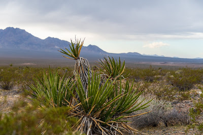
Based on these criteria, the BLM judged that the creosote bush scrub area with sparse Joshua trees in the photo at the beginning of this blog post is "low quality," or a Scenic Quality rating of "C." The mountains far in the distance earn a Scenic Quality rating of "B," or medium quality. Within a single landscape view, you are probably looking at different Scenic Quality ratings.
We can take a look at another beautiful desert valley as a case study. If you are on top of the Clipper Mountains wilderness area looking across to the Old Woman Mountains wilderness area, you are separated by fifteen miles (peak to peak) of desert in the Fenner Valley. This desert habitat in between the wilderness areas is designated as "low quality" by the BLM. The remote Fenner Valley split only by the historic Route 66, and bordered by designated wilderness is "low quality". There are no rivers, no red rock spires, no trees. Just a subtle desert valley that gently slopes down from the Clipper Mountains and back up to the next range.
Who, and How Many People Care?
The scenic quality factors I just described above are not the end of the evaluation process. Before BLM determines how it will manage visual resources in a certain area, it will consider the types of visitors to an area and how far they can see across the landscape, an analysis of "sensitivity" and visual "distances zones"
Sensitivity analysis takes into account the number and type of users in an area. Tourists and people that visit the area to appreciate the beauty of the region would be more sensitive to alteration of the landscape than people in a hurry to get somewhere. Nearby roads designated as scenic byways, or an area of critical environmental concern might also earn a landscape higher sensitivity. Many of the BLM lands in the California desert (I don't have the data for the desert areas in Nevada and Arizona) are rated as high or moderate. Distance zones tell the BLM how a landscape is viewed by folks from roads and trails - whether the land is in the foreground of a view, the background, or seldom-seen. Because the desert is so wide open, much of the Mojave and Sonoran Desert is rated as "foreground/middleground."
The sensitivity and distance zone analysis guides BLM consideration of how the land will be managed, but it does not affect the grade I described in the earlier section. As I am about to explain in the next section, that grade is arguably one of the most significant determinations in the process, especially in a process that seems to undervalue the cumulative beauty of desert landscapes.
Managing the Classes
So now that we know that most desert scenery gets a "low" or "medium" quality rating under the grading system, and that most visitors of the desert would be "highly" sensitive to alteration of the landscape and can see most of the landscape as "foreground/middleground," what does this mean for how the BLM manages the visual resources? Using all three of these buckets of criteria, the BLM assigns patches of land to one of four Visual Resource Management classes that will ultimately factor into what sorts of development the BLM would allow on the land.
The management objectives for each class are described below, but basically the lower the number, the more the BLM will try to preserve the landscape from significant alteration.
Class I : Reserved for designated wilderness. According to the BLM, "[t]he objective of this class is to preserve the existing character of the landscape. This class provides for natural ecological changes; however, it does not preclude very limited management activity. The level of change to the characteristic landscape should be very low and must not attract attention."
Class II : Lands with "The objective of this class is to retain the existing character of the landscape. The level of change to the characteristic landscape should be low. Management activities may be seen, but should not attract the attention of the casual observer. Any changes must repeat the basic elements of form, line, color, and texture found in the predominant natural features of the characteristic landscape."
Class III : This is where we start to see the BLM allow much more destructive developments. According the BLM, "[t]he objective of this class is to partially retain the existing character of the landscape. The level of change to the characteristic landscape should be moderate. Management activities may attract attention but should not dominate the view of the casual observer. Changes should repeat the basic elements found in the predominant natural features of the characteristic landscape." So what is distracting but not dominating? The BLM approved Duke Energy's Searchlight Wind project on Class III lands in southern Nevada, even though Class II lands and wilderness are immediately adjacent to the wind project, and the turbines would be visible to hikers in the Mojave National Preserve. The project would consist of 87 wind turbines each taller than the Statue of Liberty, 35 miles of new roads, and 16 miles of new transmission and collector lines.
Class IV : If your favorite patch of desert is on Class IV lands, forget about it. According to the BLM, "[t]he objective of this class is to provide for management activities which require major modifications of the existing character of the landscape. The level of change to the characteristic landscape can be high. These management activities may dominate the view and be the major focus of viewer attention." The lands in the foregound/middleground of the photo at the beginning of this blog post taken in the Lucerne Valley are identified as Class IV.
Copied below is the BLM table showing how all of the ratings and grades determine the visual resource inventory class (I - IV). Sensitivity rating (High/Medium/Low) on top, the Scenic Quality rating (A, B, C) on the left, and distance zone (foreground/middleground, background, seldom-seen) on the bottom.

Managing Visual Resources at the Landscape Level
The BLM should reconsider how it manages visual resources, particularly in the southwestern United States where currently unobstructed scenic areas can be easily marred by poorly-sited projects. Not only do the Scenic Quality ratings undervalue the desert landscape, the visual resource inventory classes are applied in such a fragmented patchwork that they are inadequate to protect the desert's grand vistas as a whole. The millions of visitors streaming through desert parks, and others enjoying scenery along quiet desert byways is a testament to the fact that the BLM's scenic quality ratings do not reflect the value the public places on desert scenery. The DRECP would be a good opportunity for this revision in the California Desert District, but we should also reassess our visual resources in Nevada and Arizona, as well.
Given the scarcity of these vistas in the southwest, the BLM should review desert resource management plans in a way that seeks to protect more of these landscapes and apply classes in a way that preserves "beyond the horizon" viewing opportunities, perhaps in new "scenic regions" or zones. I will admit that I am biased and would prefer to designate the entire desert as a conservation area, but objectively speaking, considerations for such scenic regions could include public demand, and the relative level of human disturbance to identify accessible but relatively intact scenery.
Maps
Below is a map of the Visual Resource classes in the California Desert District produced for the Desert Renewable Energy Conservation Plan, but I would caution that there are some errors in this map, such as some missing wilderness areas.
The map below is from the Las Vegas Resource Management plan, and shows visual resource inventory classes for southern Nevada.
Below is a map of Arizona's visual resource inventory. Blue is Class I (wilderness), green is Class II, yellow is Class III, and red is Class IV. Notice the abundance of Class IV in the northwest, and even north of the gorgeous Organ Pipe Cactus National Monument. Also, there is plenty of class III land north of the Grand Canyon. Arizona's visual resource inventory strongly suggests that they apply low scenic quality status to desert wildlands, and the inadequate patchwork of management is also evident in some areas.
 |
| This photo of the Lucerne Valley was taken from the Bighorn Mountain wilderness area boundary pointing west/northwest toward the Granite Mountains far in the distance. Under the BLM's visual resources management plan for the California Desert District, this patch of desert offers only "low quality" scenic resources, and will be managed to allow structures that can undermine a view that I hope many readers of this blog would find beautiful. |
Grading the Desert's Beauty
Figuring out how to save this resource requires understanding of how it is currently managed. Much of the desert beyond and between our cities in the southwest is managed by various agencies - the Bureau of Land Management, Fish and Wildlife Service, National Park Service, the U.S. Forest Service, and the Department of Defense. We will focus on the Bureau of Land Management (BLM) because visual resources in the desert are impacted the most by the BLM permitting of various projects, including transmission lines, pipelines, solar, wind, and transportation projects.
The way you and I might grade the beauty of the desert is much different than how the BLM evaluates this resource under Visual Resource Management plans. Public lands are graded based on a number of factors to determine overall scenic quality with grades of A, B, or C, according to the BLM's Visual Resources handbook. The BLM considers the following factors when evaluating the beauty of a desert landscape, which can earn 0-5 points under each factor, with more points awarded to more favorable features, and less points to less desired or spectacular features. The BLM adds up the points after evaluating each factor. A total of 19 or more points gives the landscape a Scenic Quality rating of "A," 12 to 18 points will earn the landscape a rating of "B," and 11 or less points is a "C" rating. The factors considered and how they are evaluated seem to produce ratings that are biased against the ecosystems of our basin and range deserts.
Factors considered when determining the Scenic Quality rating of public lands:
Landform: Five points for "[h]igh vertical relief as expressed in prominent cliffs, spires, or massive rock outcrops, or severe surface variation or highly eroded formations including major badlands or dune systems; or detail features dominant and exceptionally striking and intriguing such as glaciers." Only one point if the landscape consists of "[l]ow rolling hills, foothills, or flat valley bottoms; or few or no interesting landscape features. " Most of the Mojave Desert includes some impressive ranges, but perhaps not as severe in appearance to earn five points, based on how I read this rating. The subtle alluvial fans and bajadas around and between these desert mountains, and the flat playas are not appreciated by the criteria in the landform factor.
Vegetation: A rain forest would get five points, but the desert may be at a disadvantage. Although this factor does evaluate seasonal wildflower displays and "intriguing" plant life such as "gnarled or windbeaten trees, and Joshua trees," some of my favorite landscapes are dominated by creosote bushes and other shrubs that may not strike a BLM evaluator as presenting the "variety of patterns, forms, and textures" that earn higher marks. How much the BLM values perennial displays is not clear, and it is also not clear if the seasonal appearance of perennial plants at a level less than a "spectacular" display is considered.
Water: Let's face it, the desert doesn't have much water, and I highly doubt the BLM will give the desert any credit for its hidden springs and dry washes that only come to life during rare storms. And where there are rivers in the desert, some of the water flow is actually underground, as is the case with the Mojave River. According to the BLM, water is "[t]hat ingredient which adds movement or serenity to a scene. The degree to which water dominates the scene is the primary consideration in selecting the rating score." I think the desert will typically score low on this factor, although I think water does not have the monopoly on serenity.
Color: The desert has some very beautiful and striking color in some of its landscapes, such as in Red Rock Canyon National Conservation Area and the Gold Butte area, both in Nevada. Presumably these areas would score high in color, since the BLM's scenic quality standards require "[r]ich color combinations, variety or vivid color; or pleasing contrasts in the soil, rock, vegetation, water or snow fields," in order to score the full five points. However, I suspect most of the Mojave and Sonoran Desert areas rate substantially lower with "[s]ubtle color variations, contrast, or interest; generally mute tones." Again, I think the subtlety of the desert is what I find so pleasing, and I do not think the BLM considers how the landscape is complemented by different times of day as shadows from a rising or setting sun can stretch across miles of open desert, and the sky can light up in purples and pinks hues.
Influence of adjacent scenery: According to the BLM, the "[d]egree to which scenery outside the scenery unit being rated enhances the overall impression of the scenery within the rating unit. The distance which adjacent scenery will influence scenery within the rating unit will normally range from 0-5 miles, depending upon the characteristics of the topography, the vegetative cover, and other such factors" I suspect that if adjacent scenery is not "spectacular," a desert valley is unlikely to get many points under this factor. For me, adjacent scenery that is equally undisturbed by human development results in a cumulatively greater experience. The further I can see without being distracted by cities or industries, the more beautiful the view. It doesn't matter if the spires of Monument Valley are in the distance, or simply more basins and ranges.
Scarcity: This is the one factor where public lands can earn more than five points, although the evaluation would have to justify the extra credit. According to the BLM's Visual Resources Management handbook, "[t]here may also be cases where a separate evaluation of each of the key factors does not give a true picture of the overall scenic quality of an area. Often it is a number of not so spectacular elements in the proper combination that produces the most pleasing and memorable scenery - the scarcity factor can be used to recognize this type of area and give it the added emphasis it needs." In my book, the desert deserves a lot of extra credit points under this factor because the other individual factors used to evaluate my favorite desert places do not adequately capture the cumulative majesty of desert landscapes. As I mentioned at the beginning of this blog post, these "beyond the horizon" views in the desert are also under threat of more development that would spoil the scenic qualities most of us enjoy, so they would seemingly qualify for "scarcity" points.
Cultural Modifications: This basically evaluates other human development in the area, although it considers that some modifications may actually enhance or complement the beauty of a scene. Although I would not advocate for paving more roads across the desert, I think looking down a lonely two-lane highway can accentuate the contours and distance of a desert view. Similarly, old timbers and rails from abandoned mining camps from the late 1800s and early 1900s can also be an intriguing feature that I would find complementary to a desert view that is otherwise undisturbed. Transmission lines, large agricultural fields, and other projects detract from the beauty, in my opinion.
Based on these criteria, the BLM judged that the creosote bush scrub area with sparse Joshua trees in the photo at the beginning of this blog post is "low quality," or a Scenic Quality rating of "C." The mountains far in the distance earn a Scenic Quality rating of "B," or medium quality. Within a single landscape view, you are probably looking at different Scenic Quality ratings.
 |
| The Old Woman Mountains in the distance, with the Clipper Mountains behind the photographer. Open desert dominated by the creosote bush. Sunset shot of this same area can be found in the blog of the "DzrtGrls." |
Who, and How Many People Care?
The scenic quality factors I just described above are not the end of the evaluation process. Before BLM determines how it will manage visual resources in a certain area, it will consider the types of visitors to an area and how far they can see across the landscape, an analysis of "sensitivity" and visual "distances zones"
Sensitivity analysis takes into account the number and type of users in an area. Tourists and people that visit the area to appreciate the beauty of the region would be more sensitive to alteration of the landscape than people in a hurry to get somewhere. Nearby roads designated as scenic byways, or an area of critical environmental concern might also earn a landscape higher sensitivity. Many of the BLM lands in the California desert (I don't have the data for the desert areas in Nevada and Arizona) are rated as high or moderate. Distance zones tell the BLM how a landscape is viewed by folks from roads and trails - whether the land is in the foreground of a view, the background, or seldom-seen. Because the desert is so wide open, much of the Mojave and Sonoran Desert is rated as "foreground/middleground."
The sensitivity and distance zone analysis guides BLM consideration of how the land will be managed, but it does not affect the grade I described in the earlier section. As I am about to explain in the next section, that grade is arguably one of the most significant determinations in the process, especially in a process that seems to undervalue the cumulative beauty of desert landscapes.
Managing the Classes
So now that we know that most desert scenery gets a "low" or "medium" quality rating under the grading system, and that most visitors of the desert would be "highly" sensitive to alteration of the landscape and can see most of the landscape as "foreground/middleground," what does this mean for how the BLM manages the visual resources? Using all three of these buckets of criteria, the BLM assigns patches of land to one of four Visual Resource Management classes that will ultimately factor into what sorts of development the BLM would allow on the land.
The management objectives for each class are described below, but basically the lower the number, the more the BLM will try to preserve the landscape from significant alteration.
Class I : Reserved for designated wilderness. According to the BLM, "[t]he objective of this class is to preserve the existing character of the landscape. This class provides for natural ecological changes; however, it does not preclude very limited management activity. The level of change to the characteristic landscape should be very low and must not attract attention."
 |
| The Nopah Mountains wilderness pictured above includes much of the desert in the middleground, and is listed as Class I Visual Resources because it is designated wilderness. |
Class II : Lands with "The objective of this class is to retain the existing character of the landscape. The level of change to the characteristic landscape should be low. Management activities may be seen, but should not attract the attention of the casual observer. Any changes must repeat the basic elements of form, line, color, and texture found in the predominant natural features of the characteristic landscape."
 |
| Much of the desert in the Silurian Valley north of Baker, California is designated as Class II, although Iberdrola Renewables proposes to build a large solar and wind facility here. Oddly, the Avawatz Mountains in the distance are rated as Class III. |
 |
| This is Class III land, although much of this view is now spoiled by BrightSource Energy's 5.6 square mile Ivanpah Solar project. Perhaps BLM rated the Ivanpah Valley as Class III because of existing disturbances such as the highway and small gambling outpost of Primm, but I'm not sure how they concluded that the solar project does not "dominate" the landscape. Despite the pre-existing development, much of the Ivanpah Valley was still beautiful, and probably had the same (or less) relative disturbance as the Yosemite Valley. |
 |
| Some ugly Class IV land southeast of Barstow, outside of the Newberry Mountain wilderness area . No Visual Resources to protect here. |
Copied below is the BLM table showing how all of the ratings and grades determine the visual resource inventory class (I - IV). Sensitivity rating (High/Medium/Low) on top, the Scenic Quality rating (A, B, C) on the left, and distance zone (foreground/middleground, background, seldom-seen) on the bottom.

Managing Visual Resources at the Landscape Level
The BLM should reconsider how it manages visual resources, particularly in the southwestern United States where currently unobstructed scenic areas can be easily marred by poorly-sited projects. Not only do the Scenic Quality ratings undervalue the desert landscape, the visual resource inventory classes are applied in such a fragmented patchwork that they are inadequate to protect the desert's grand vistas as a whole. The millions of visitors streaming through desert parks, and others enjoying scenery along quiet desert byways is a testament to the fact that the BLM's scenic quality ratings do not reflect the value the public places on desert scenery. The DRECP would be a good opportunity for this revision in the California Desert District, but we should also reassess our visual resources in Nevada and Arizona, as well.
Given the scarcity of these vistas in the southwest, the BLM should review desert resource management plans in a way that seeks to protect more of these landscapes and apply classes in a way that preserves "beyond the horizon" viewing opportunities, perhaps in new "scenic regions" or zones. I will admit that I am biased and would prefer to designate the entire desert as a conservation area, but objectively speaking, considerations for such scenic regions could include public demand, and the relative level of human disturbance to identify accessible but relatively intact scenery.
- The Route 66 corridor that also falls within a proposed monument under the California Desert Protection Act of 2011 would be one zone that is accessible and only minimally affected by modern human development.
- The Pahrump Valley from the town of Pahrump to the southern edge of the Spring Mountains would complement the spectacular views on the California side of the border.
- The Piute Valley in southern Nevada is another beautiful area bordered by mountain wilderness, including the culturally significant Spirit Mountain (assuming the Searchlight Wind project is withdrawn).
Maps
Below is a map of the Visual Resource classes in the California Desert District produced for the Desert Renewable Energy Conservation Plan, but I would caution that there are some errors in this map, such as some missing wilderness areas.
The map below is from the Las Vegas Resource Management plan, and shows visual resource inventory classes for southern Nevada.
Below is a map of Arizona's visual resource inventory. Blue is Class I (wilderness), green is Class II, yellow is Class III, and red is Class IV. Notice the abundance of Class IV in the northwest, and even north of the gorgeous Organ Pipe Cactus National Monument. Also, there is plenty of class III land north of the Grand Canyon. Arizona's visual resource inventory strongly suggests that they apply low scenic quality status to desert wildlands, and the inadequate patchwork of management is also evident in some areas.
 |
| [click on image to expand] |


Thanks for this thorough post - what is considered or valued as scenic on an official designation leaves much to be desired. I see their points to how they classify, but this is proof of missing the point of good stewardship. Those are all some stunning views in their own way, not to mention what lives there not in view. Perhaps Class IV = no forested mountains, OK to discard your old appliances here...
ReplyDeleteI have a way to finish really reading it after skimming, but it will be worth it.
It kind of blows my mind that the BLM attempts classifications of visual value.. it's romantic and seems totally precarious at the same time - especially seeing beautiful landscapes score so low and designated for demolition (development).
ReplyDeleteIs the scoring system put in place to aid development or conservation?