Posts

Showing posts from 2014

Tortoise Toll Mounts at Nevada Solar Project

Image
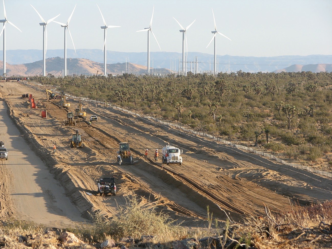
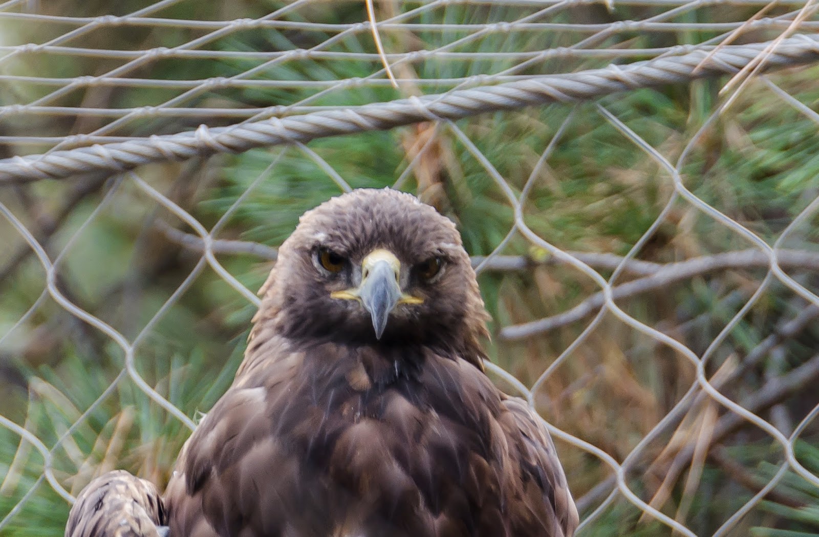
First Solar's Silver State South project has displaced over 152 desert tortoises, according to data obtained by Basin and Range Watch , and this toll is expected to rise since construction crews have not yet finished bulldozing the threatened animal's habitat.  The Silver State South solar project is being built just east of Primm, Nevada on 3.7 square miles of intact Mojave Desert habitat that biologists have determined to be a key corridor for the desert tortoise - facilitating genetic flow for the species that is important for its survival in the face of many anthropogenic threats, including climate change. A giant cholla cactus on the site of First Solar's Silver State South Solar project.  This cactus' size suggests it has survived for a long time in the arid and harsh climate of the Mojave Desert, but it will be destroyed to make way for an energy project that allows us to charge our iPhones and run our air conditioners.  The same solar panels that will displ

Overriding Considerations and the War on Carbon

Image
The New York Times recently published an Op-Ed by author Rebecca Solnit questioning our concern for the fate of wildlife as we rapidly expand renewable energy generation.  Ms. Solnit's point seems to be that the climate catastrophe poses far too great of a threat to be concerned for the death of wildlife at solar and wind energy projects.  I think it is very timely that her op-ed was published at the same time that our country is left trying to explain why the torture of a few was necessary for the defense of many.  When we are left questioning why we should compromise on our values in the pursuit of victory in war.  A swallow found dead at BrightSource Energy's Ivanpah Solar power project, almost certainly burned by the "solar flux" - superheated air - generated by the project's thousands of giant mirrors. I would like to argue that Ms. Solnit is missing the point, and that every life has value, including every single bird and insect burned at BrightSourc

Conservation Legislation Loaded with Poison Pills

Congress may grant public lands some new conservation designations before the end of the year, but at a substantial cost.   The House of Representatives and Senate have agreed on draft legislation that will pair conservation proposals with land transfers and special allowances for the mining, timber, grazing and energy interests.  The Senate is expected to pass the bill, which also includes the long-sought Tule Springs Fossil Beds National Monument north of Las Vegas.  In the last days of a Democrat-controlled Senate, it is a dismal sign of the times to come if even "bi-partisan" conservation deals are so heavily laden with gifts to industry. Nevada's New Monument If the legislation passes the Senate - a move expected within the next week - it would establish the Tule Springs Fossil Beds National Monument on over 22,000 acres just north of Las Vegas.  However, the monument would come with its own dose of destructive compromises.  The bill directs the National Park Ser

Close the Coolwater Natural Gas Plant

San Bernardino County's ozone levels are ridiculous.  According to the Los Angeles Times, San Bernardino can reach ozone levels of 107 parts per billion (ppb), which is bad for our health and the environment.  The current standard for ozone levels is 75 ppb, set by the Bush administration, but even this is seen as too high.  The Obama administration is proposing to adjust the standard down to 65 - 70 ppb.  Whether we stick with the unhealthy standard of 75 ppb, or go lower, San Bernardino Count has clearly been negligent in addressing a serious health problem, and should be conisdering bold steps to clean up its act.  One obvious step would be to shut down the Coolwater natural gas plant just east of Barstow in the heart of San Bernardino County.  This old natural gas facility is reaching the end of its life, and contributes to congestion on power lines that inhibits the addition of renewable energy.  Southern California Edison (SCE) - the local utility company that also buys po

Silurian Valley Spared by BLM

Image
If you have ever been to the Silurian Valley, you know it is one of those grand places that inspires and beckons you to pull over, get out of your car, and hike.  After driving on Interstate 15 from Barstow, the Silurian Valley is a strong dose of tranquility, providing relief from the traffic, billboards and franchise restaurants of our Anthropocentric world and what Aldo Leopold called the "epidemic of geometry."  As you drive up the two-lane Death Valley Road,  you leave behind the sight of the small highway outpost of Baker and you are swallowed by the immensity of the Silurian Valley. It is just you and the narrow road dividing thousands of acres of wilderness on either side.  This week, Jim Kenna, the State Director for the Bureau of Land Management (BLM) in California, spared this place for future generations to experience when he rejected plans by Spain-based Iberdrola to build the Aurora Solar project. The Silurian Valley, with the Avawatz Mountains far in

Investigation Sheds Light on Industry Influence over Desert Policy

Image
The Inspector General (IG) of the Department of Interior released a report this month confirming that a senior Obama administration official with cozy ties to the renewable energy industry pressured subordinates to ignore environmental concerns in favor of providing rubber-stamp approval to power plants.  The IG report focuses on the actions of Steve Black - who retired from Interior in 2013 and served as senior counselor to former Secretary of Interior Ken Salazar  - because he dated a lobbyist for renewable energy company NextEra and also put his name forward to serve as CEO of the American Wind Energy Association (AWEA), all while continuing to manage the approval of renewable energy projects on public lands.  At the very least, Mr. Black's actions constitute the appearance of impropriety that undermines our ability to trust Interior leadership to manage public lands based on sound science rather than special interests. As senior counselor to the Secretary of Interior, Black

Celebrating the Desert Protection Act

Image
Senator Dianne Feinstein's California Desert Protection Act (CDPA) was signed into law 20 years ago on October 31, 1994, establishing new protections for vast stretches of the desert.  The CDPA established 69 new Wilderness areas,  created the Mojave National Preserve, converted Death Valley and Joshua Tree National Monuments into National Parks, and added acreage to both parks. Watching the sun set in a remote corner of the Mojave forges a connection between me and generations past, and it would be nice to know that future generations will share the same natural heritage.  Witnessing mountain shadows gently stretch across miles of open desert, hearing coyotes howl at twilight as bats flutter by, and being immersed in an infinite blanket of stars overhead are some of the treasured experiences you can have in the desert.  Clouds stroll across the sky during the midday in the Mojave National Preserve, casting shadows on the mountains and valley. These experiences are incre

DRECP Spotlight: Cuddeback

Image
When I was a kid growing up in Victorville watching jets taking off from now-closed George Air Force Base, I didn't know that some of them were probably bombing a 12 square mile patch of desert in California known as the Cuddeback Air Force Bomb and Gunnery Range.  The U.S. Air Force gave up the Cuddeback range in August 2012, but the Bureau of Land Management (BLM) is still figuring out whether it is " suitable for public use ."  The Desert Renewable Energy Conservation Plan (DRECP) does not designate the Cuddeback range as either a development focus area or a conservation area, even thought it is immediately adjacent to two wilderness areas, and probably serves as important habitat for the desert tortoise and Mojave ground squirrel. The Google map above shows the approximate boundaries of the former Cuddeback Air Force Range.  The DRECP does not recognize the range as BLM land, even though Department of Interior testimony acknowledged that the U.S. Air Force relinq

DRECP Spotlight: Bats

Image
According to the Desert Renewable Energy Conservation Plan ( DRECP ), a full build-out of the anticipated wind energy target in the California desert region would kill from 4,000 to 283,000 bats each year (page IV.7-273).   This estimate assumes 2,023 turbines would be installed in development focus areas in the western Mojave, Lucerne Valley, Chocolate Mountains and Imperial Valley. The wide range in the bat death estimate - a spread of over 270,000 - shows just how little we know about how renewable energy in the desert will impact bats.  The wind industry does not always cooperate with independent studies on wildlife impacts, and the industry funds the American Wind Wildlife Institute to shape the public discussion on this topic in a way that is favorable to industry. The moon sets in the western Mojave desert during the early dawn hours.  I don't have my own picture of a bat because I'm not that good of a photographer. I have not seen any information in the DRECP

Renewable Energy World Slips on DRECP Coverage

Image
Online industry magazine Renewable Energy World declared in a recent article that the Desert Renewable Energy Conservation Plan (DRECP) "kneecaps" the renewable energy industry, inaccurately arguing that 3,162 square miles of development focus areas is not enough for the industry.  This is my attempt to deconstruct the article's overall lack of understanding of the DRECP and the state of renewable energy in the California desert: Claim 1:   The energy industry will be handicapped by the DRECP because 80 percent of the development focus areas are on private lands, and it is too difficult for the industry to acquire and develop private lands:   Response:  This is not consistent with facts on the ground.  There are nearly 4,000 megawatts of wind and solar projects approved, under construction or operational on non-federal lands in the DRECP area, indicating that industry has easily acquired and developed private lands.  These include projects with a capacity of hundred

Juniper Flats Safe For Now

Image
Activists in the Lucerne and Victor Valleys received good news from the BLM this past week that plans for the North Peak Wind project had been withdrawn.  The project would have industrialized  nearly 16 square miles of a popular outdoor recreation area known as Juniper Flats popular for hiking and horseback riding, where desert habitat transitions from creosote and yucca scrub to chapparal, grassland and desert conifer.  Groups such as the Alliance for Desert Preservation and Mojave Communities Conservation Collaborative quickly organized to protect Juniper Flats, as well as to challenge the proposed Coolwater-Lugo Transmission project , which is still pending. The hills in the background would have been carved up by wide access roads to reach newly installed wind turbines, which would have towered over the subtle peaks and erased the sense of peace and solitude that visitors find when visiting Juniper Flats. Although it is not yet clear why the company withdrew the wind p

Nevada: Draft Plan Would Endanger Natural Treasures

Image
The Bureau of Land Management (BLM) put forward a draft resource management plan (RMP) for southern Nevada that ignores opportunities to protect lands with wilderness characteristics and proposes industrial-scale energy development near natural landmarks.  The draft RMP adds to the extraordinary burden that desert activists face as they comb through the Desert Renewable Energy Conservation Plan for neighboring California; comparing the two plans highlights how bureaucratic boundaries can result in arbitrary differences in how we manage desert wildlands. Wildlands Sidelined The RMP acknowledges that an inventory of desert habitat identified over 378 square miles of land with wilderness characteristics - sufficient size, naturalness, and outstanding opportunities for either solitude or primitive and unconfined recreation - that could be managed to preserve these attributes. However, the preferred alternative would only protect about 15% of these lands. This area in t

DRECP Spotlight: Conservation Designations

Image
My last couple of Spotlights focused on how the Desert Renewable Energy Conservation Plan designates areas where large-scale renewable energy projects will be considered and fast-tracked, including development focus areas (DFAs), special analysis areas, and future assessment areas.  In an attempt to balance this destruction with conservation, the DRECP also identifies lands to be protected from various forms of destruction.  The types of DRECP conservation designations for lands in the California desert vary depending on whether the land is administered by the Bureau of Land Management (BLM) or private (non-federal). BLM Conservation Designations While the DRECP bestows conservation designations on some key BLM lands in the California desert,  the designations may not be very durable because they can be lifted in a future revision of a BLM land use plan.   This is particularly troubling because the projects built on DFAs will leave their mark on the landscape and ecosystem for

DRECP Spotlight: Development Focus Areas

Image
The draft Desert Renewable Energy Conservation Plan identifies 2,024,000 acres (3,162 square miles) of "development focus areas" (DFA) in the preferred alternative.  Of that total, 367,000 acres (573 square miles) are on lands administered by the Bureau of Land Management (BLM).  I wrote yesterday about the assumptions that were used to come up with this many acres of DFAs. DFAs By County: The following numbers include a both private and BLM-administered lands.  Imperial County shoulders the heaviest DFA burden at 734,000 acres (1,146 square miles), followed by San Bernardino County at 399,000 acres (623 square miles), Kern County at 360,000 acres (562 square miles), Riverside County at 268,000 acres (418 square miles), Los Angeles County at 218,000 acres (340 square miles), and Inyo County at 45,000 acres (70 square miles). Construction crews bulldozing Joshua tree woodland habitat in Kern County to make way for a wind energy facility.  Most of the wind facili

DRECP Fact of the Day: 20,000 Megawatts

Image
This is an important number in the Desert Renewable Energy Conservation Plan (DRECP).  The State and Federal agencies that drafted the DRECP start with the assumption that the California desert region may need to host at least 20,000 megawatts of large-scale wind, solar or geothermal energy projects by the year 2040.  Based on this assumption, the DRECP agencies calculated how many acres would need to be designated as development focus areas (DFAs) to accommodate these 20,000 megawatts. This is what the DRECP does not mention: a study by the UCLA's Luskin Center for Innovation calculated that the rooftops in Los Angeles County alone could accommodate over 22,000 megawatts of solar panels.   As I pointed out in my earlier post on the DRECP, the plan unfortunately discarded an alternative that would consist only of distributed generation (solar panels on rooftops, over parking lots, and other spaces in our cities).   The DRECP's purpose and need statement ( Volume I.1 ) m

DRECP Fact of the Day: Eagles

Image
Golden eagles soar over the Mojave Desert. We know that wind turbines and golden eagles do not mix well.  Solar power towers - like those that BrightSource and NRG built in the Ivanpah Valley - can burn eagles alive.  And sprawling photovoltaic solar plants can destroy the wildlands where golden eagles like to forage for food.   The U.S. Fish and Wildlife Service (FWS) is responsible for monitoring the status of the golden eagle, and determining whether or not any industry - including the renewable energy industry - is permitted to "take" (harass or kill) golden eagles.  (Note: the golden eagle is not an endangered species, but it is protected under the Bald and Golden Eagle Protection Act ) A golden eagle recovering from an injury at the High Desert Museum in Bend, Oregon.  These birds face a number of threats from humans, including climate change, power lines, strikes with vehicles, and wind turbines. According to Appendix H of the Desert Renewable Energy Conservat

DRECP: First Impressions

The draft Desert Renewable Energy Conservation Plan (DRECP) was released at the end of September, almost 34 years after the Department of Interior finalized its original plan for managing the vast and beautiful California Desert Conservation Area.  With nearly 8,000 pages and extensive reformulation of land use policies throughout 22 million acres of California, the DRECP will take a while to digest and formulate thorough comments.  This plan will shape the future of one of the largest intact ecosystems remaining in the lower 48 United States, so it will be worth the time to review and provide input. By the Numbers - Energy Industrialization 3,146 square miles:  The number of square miles of "Development Focus Areas" (DFA) designated by Federal and State agencies in the preferred alternative where large-scale wind, solar, and geothermal energy development will be encouraged or fast-tracked.   Although it is important to note that the DRECP does not anticipate that ever