BLM Reviewing Route 66 Management in California
Route 66 is an important artery providing access to California's Mojave Desert. Like the two-lane "Outback Highway" that runs mostly north/south through the region, Route 66 provides east/west access to stunning desert vistas still mostly unharmed by man, giving visitors a chance to share a common experience with past generations. The Bureau of Land Management (BLM) and California Historic Route 66 Association are now developing a Corridor Management Plan (CMP) that seeks to align county and Federal efforts to protect this historically significant corridor.
I am excited about the potential for the CMP to make a visit to the California Desert a richer experience, with more opportunities for folks to learn about and appreciate the history, culture and environment. When it was first established, Route 66 was part of the evolution of the "faster is better" mindset and engineering that has robbed people of their ability to experience the Mojave, but the "Mother Road" has since been overtaken by interstate highways where people zoom along at much higher speeds to get from point A to Z without appreciating the rest of the alphabet. The CMP provides an opportunity to slow folks down, and build appreciation for our cultural and natural heritage in the Mojave.
Meetings for the CMP thus far have been focused on revitalizing the tourism values along the corridor, which obviously overlap with, and have implications for our desert conservation efforts. Based on a review of meeting and planning materials posted online, here are some of my thoughts on the CMP and protecting the desert:
Visual Resources
The CMP hopefully will take a look at BLM's Visual Resource classifications along the corridor, which currently do not reflect the same value that visitors behold in the open desert landscape along Route 66. Most of the corridor is rated Visual Resource class III, one of the lowest ratings that subsequently allows for substantial industrial-scale destruction of the landscape (I have previously written about the problem with visual resource management in the desert - the creosote scrub habitat along Route 66 typically scores a "low" or "moderate" in BLM's scenic quality ratings). Adjusting the Visual Resource classes along the Route 66 corridor should acknowledge one of the Mojave's most beautiful qualities - largely natural, unbroken vistas that provide us with an escape from the ubiquitous maze of billboards and strip malls from which we hail. Open scenery where we can watch thunderstorms bubble up over mountains and lumber across valleys, and the shadows of sunset and sunrise dance across miles and miles of open desert floor.
Lights Out (or Low) - Preserving Access to the Night Sky
Revitalization of businesses catering to visitors and outdoor lighting should adhere to dark sky principles to avoid competing with the dazzling night sky. The night sky is also part of the visitor experience. Almost everyone I talk to on the east coast about the desert camping experience talks about seeing the stars. When we're in the city, you're lucky when you can see a handful through the light pollution. In the desert, the vastness of the landscape during the day is replaced by an even more vast scenery of stars and galaxies at night.
Teaching Moments
The CMP will also evaluate opportunities for interpretive roadside stops to tell the story of the road, and the geology and ecology of the Mojave Desert. This is important. Although travelers on Route 66 probably have an appreciation for the lore and mystery of Route 66 and the desert, I would not be surprised if many visitors still see the landscape as a "wasteland." The biodiversity of the desert is not always obvious if you do not know what you're looking for, so some interpretive materials and events that educate visitors about the desert will go a long way toward disabusing people of the "wasteland" notion.
Take it Easy - Low-Impact Travel
Speeding vehicles and wide highways can impede wildlife movement across a landscape, as we have seen with Interstates 40 and 15. Route 66 should be a road for folks that want to slow down and enjoy the scenery, not a high speed dash to Las Vegas, and the recent Transportation meeting by the Ad Hoc Planning Committee considering the CMP discussed how to repair and revitalize this section of Route 66 without encouraging excessive speed. I am glad this is being considered, since any modifcations that encourage faster travel is only going to erode the good qualities of the corridor.
This section of Route 66 crosses over 128 wooden trestle bridges nearly 80 years old that lift the road above desert washes. The CMP will discuss rehabilitation of these structures and ensuring proper drainage. If the plan is looking to maintain the integrity of the desert, it should ensure that any modifications preserve the ability of wildlife to move across or under the road. Maintaining a desert substrate - vegetation and soils that support and encourage the movement of wildlife - underneath the bridges would be helpful.
One suggestion highlighted in materials for an Ad Hoc Planning Committee mentions the potential to add bike trails along the road. This would be an excellent opportunity to encourage visitors to see and experience Route 66 and the surrounding desert in a different way.
An Extended Stay
The desert can often be a daunting place for the uninitiated, but some visitors may want to stay long enough to see a night sky, go for hikes in the wilderness areas along the Route 66 corridor, or use Route 66 as a base camp to explore beyond Route 66 into the Mojave National Preserve. The BLM could do better to establish, maintain, and publicize recreation opportunities that will encourage more folks to experience this part of the desert. For example, finding hikes in the wilderness areas along Route 66 would require some fairly sophisticated Internet searches, combined with some cross-referencing from BLM maps to Google Maps to figure out where to go without getting lost. And once you arrive, you probably will not find any well-marked trail heads or trails.
Once you finish a hike, you may not feel like driving all the way back to the city, or you'd like to reward yourself with a view of the sunset, the howl of coyotes at night, or a beautiful sunrise. BLM could create or identify primitive camp sites in the area, and provide better access to materials that direct visitors to these sites and encourage responsible, leave-no-trace use. Although I prefer to camp in a quiet corner of the desert (away from the road), not everybody has the will or ability to camp - or maybe they need a stepping stone to get them to that point. The County could incentivize the revitalization of some low-impact tourism accommodations - such as opening up motel space at the old Roy's Motel and Cafe. This would provide more people with an opportunity to extend their visit beyond the couple of hours they may spend driving down the road during a day trip.
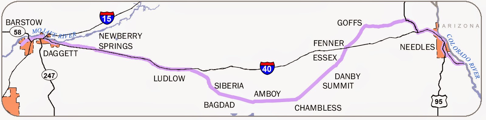 |
| A map from the California Historic Route 66 Association website shows the portion of the Route 66 corridor that will be reviewed for the Corridor Management Plan. From Needles to just west of Barstow is about 160 miles of history, culture, and beautiful desert scenery. |
Meetings for the CMP thus far have been focused on revitalizing the tourism values along the corridor, which obviously overlap with, and have implications for our desert conservation efforts. Based on a review of meeting and planning materials posted online, here are some of my thoughts on the CMP and protecting the desert:
Visual Resources
The CMP hopefully will take a look at BLM's Visual Resource classifications along the corridor, which currently do not reflect the same value that visitors behold in the open desert landscape along Route 66. Most of the corridor is rated Visual Resource class III, one of the lowest ratings that subsequently allows for substantial industrial-scale destruction of the landscape (I have previously written about the problem with visual resource management in the desert - the creosote scrub habitat along Route 66 typically scores a "low" or "moderate" in BLM's scenic quality ratings). Adjusting the Visual Resource classes along the Route 66 corridor should acknowledge one of the Mojave's most beautiful qualities - largely natural, unbroken vistas that provide us with an escape from the ubiquitous maze of billboards and strip malls from which we hail. Open scenery where we can watch thunderstorms bubble up over mountains and lumber across valleys, and the shadows of sunset and sunrise dance across miles and miles of open desert floor.
 |
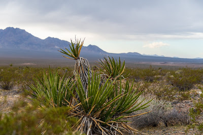
| This photo was taken from Kelbaker Road in the Mojave National Preserve, although the Route 66 corridor lies in the Fenner Valley between the Old Woman Mountains in the distance, and the Middle Hills in the mid-ground. Industrial development anywhere in the region is likely to spoil a wilderness experience across a wide swath of the desert. |
Lights Out (or Low) - Preserving Access to the Night Sky
Revitalization of businesses catering to visitors and outdoor lighting should adhere to dark sky principles to avoid competing with the dazzling night sky. The night sky is also part of the visitor experience. Almost everyone I talk to on the east coast about the desert camping experience talks about seeing the stars. When we're in the city, you're lucky when you can see a handful through the light pollution. In the desert, the vastness of the landscape during the day is replaced by an even more vast scenery of stars and galaxies at night.
Teaching Moments
The CMP will also evaluate opportunities for interpretive roadside stops to tell the story of the road, and the geology and ecology of the Mojave Desert. This is important. Although travelers on Route 66 probably have an appreciation for the lore and mystery of Route 66 and the desert, I would not be surprised if many visitors still see the landscape as a "wasteland." The biodiversity of the desert is not always obvious if you do not know what you're looking for, so some interpretive materials and events that educate visitors about the desert will go a long way toward disabusing people of the "wasteland" notion.
Take it Easy - Low-Impact Travel
Speeding vehicles and wide highways can impede wildlife movement across a landscape, as we have seen with Interstates 40 and 15. Route 66 should be a road for folks that want to slow down and enjoy the scenery, not a high speed dash to Las Vegas, and the recent Transportation meeting by the Ad Hoc Planning Committee considering the CMP discussed how to repair and revitalize this section of Route 66 without encouraging excessive speed. I am glad this is being considered, since any modifcations that encourage faster travel is only going to erode the good qualities of the corridor.
 |
| Part of the charm of Route 66 is that it's not a dangerous, fast, and enormous highway. The section above is between Goffs and Needles, south of the Mojave National Preserve. |
One suggestion highlighted in materials for an Ad Hoc Planning Committee mentions the potential to add bike trails along the road. This would be an excellent opportunity to encourage visitors to see and experience Route 66 and the surrounding desert in a different way.
An Extended Stay
The desert can often be a daunting place for the uninitiated, but some visitors may want to stay long enough to see a night sky, go for hikes in the wilderness areas along the Route 66 corridor, or use Route 66 as a base camp to explore beyond Route 66 into the Mojave National Preserve. The BLM could do better to establish, maintain, and publicize recreation opportunities that will encourage more folks to experience this part of the desert. For example, finding hikes in the wilderness areas along Route 66 would require some fairly sophisticated Internet searches, combined with some cross-referencing from BLM maps to Google Maps to figure out where to go without getting lost. And once you arrive, you probably will not find any well-marked trail heads or trails.
Once you finish a hike, you may not feel like driving all the way back to the city, or you'd like to reward yourself with a view of the sunset, the howl of coyotes at night, or a beautiful sunrise. BLM could create or identify primitive camp sites in the area, and provide better access to materials that direct visitors to these sites and encourage responsible, leave-no-trace use. Although I prefer to camp in a quiet corner of the desert (away from the road), not everybody has the will or ability to camp - or maybe they need a stepping stone to get them to that point. The County could incentivize the revitalization of some low-impact tourism accommodations - such as opening up motel space at the old Roy's Motel and Cafe. This would provide more people with an opportunity to extend their visit beyond the couple of hours they may spend driving down the road during a day trip.


Comments
Post a Comment