Will the Military Take Over the Desert National Wildlife Refuge?
The Department of Defense (DOD) is poised to release details next month regarding its proposal to take over a significant portion of the Desert National Wildlife Refuge (DNWR), close public lands, and incorporate them into the Nellis Test and Training Range. A review of documents made public so far, however, suggests DOD may be inflating its need to close public lands and assume control of the wildlife refuge. The Nellis Test and Training Range already spans 4,608 square miles, and within those vast lands there probably are opportunities to accommodate DOD's training needs without significantly eroding public access or wildlife protection. The options that DOD has proposed so far, however, seem to ignore innovative management approaches and technological solutions that can limit the impact on our public lands.
Lay of the Land:
The DOD wants to 1.) take lead jurisdiction and expand ground-disturbing activities on wildlife refuge lands that are currently managed jointly with the Fish and Wildlife Service, and 2.) close public access to additional wildlife refuge lands that currently offer popular recreation opportunities. At the Nellis Test and Training Range, ground disturbing activities can involve target impact areas (where the military can fire live ammunition against vehicles, and mock cities and airfields), installation of threat emitters (equipment designed to simulate threats against aircraft to make the training more realistic), and roads connecting these facilities to allow for training of ground forces or access for maintenance crews.
There
is no doubt that modern military equipment and tactics require DOD to
revise its training scenarios. But does the DOD need access to more
land to accomplish these scenarios? The Nellis Test and Training Range already
encompasses 4,608 square miles of land, and it is part of nearly 21,000 square miles of DOD combat training and testing areas throughout the southwestern United States. The
portion of the existing Nellis Test and Training Range that overlaps
with DNWR encompasses 1,316 square miles. On these overlapping
lands, the Fish and Wildlife Service maintains lead jurisdiction, and
DOD is allowed to drop munitions and drive vehicles on a portion
of those overlapping lands. Even though DOD has full control of the remaining 3,292 square miles of
the Nellis Test and Training Range, it claims that it needs to be able to do more on wildlife refuge lands. To do that, it wants primary jurisdiction over these wildlife refuge lands.
DOD's proposal to take control of wildlife refuge lands that are currently jointly managed is worrisome because DOD would be able to significantly expand habitat destruction to build mock urban areas or airfields, build maintenance yards, expand target impact areas, and construct new roads to connect new infrastructure. DOD calls this aspect of the proposal "ready access." An Air Force study in 2016 indicated that military crews responsible for setting up targets deep in the Nellis Test and Training Range complained about having to drive long distances to do their work. The report stated that if DOD took control over the wildlife refuge they could build more roads that would shorten their commute. The report also suggests that DOD could build new targets and "threat emitters" - facilities that simulate threats to aircraft during training exercises - if DOD is able to roll back protections for wildlife refuge lands.
DOD is attempting to assuage public concerns by stating that it would still have to follow some environmental laws if it took primary jurisdiction of the wildlife refuge lands. But the law would still permit DOD to build more targets, create more impact areas, and build roads and other structures.
The Air Force has built mock cities and airfields in other parts of the Nellis Test and Training Range that cumulatively add up to significant destruction of desert wildlands.
A better solution would be for DOD and the Fish and Wildlife Service to maintain joint management of the lands, and have DOD identify specific changes that it needs to accomplish its evolving training scenarios. For example, the environmental impact statement could identify specific roads or threat emitter sites that need to be built, rather than proposing sweeping changes in jurisdiction or public land protections.
DOD should also examine the extent to which it could use already-available lands in the Nellis Test and Training Range to accomplish its mission, or invest in virtual threats that reduce the need to build new roads and structures on the range. According to an Air Force spokesperson interviewed by Air Force magazine:
Permanent Closure of DNWR Lands Probably Unnecessary
The DOD's proposal to shut down public access to another 354 square miles within the wildlife refuge, including the popular Alamo Road, is also troubling because the military appears to be ignoring more flexible options that can balance public access and safety. Alamo Road provides access to multiple camping and hiking spots in the DNWR. DOD states that the lands encompassing Alamo Road are adjacent to Range 62A - one of many target impact areas in the Nellis range. Up until now, military aircraft approach the target impact areas in Range 62A from directions and altitudes that minimize risk to people that may be camping or hiking in adjacent refuge lands. But now the military wants its aircraft to approach the targets in Range 62A from multiple directions and drop weapons from higher altitudes, therefore putting the adjacent public lands at greater risk.
However, the DOD could simply impose temporary access restrictions during the times of year that it needs to conduct such exercises. DOD imposes similar temporary restrictions at Twentynine Palms Marine Corps Air and Ground Combat Center and the White Sands Missile Range. At Twentynine Palms, the USMC temporarily closes a portion of Johnson Valley to the public during training exercises each year. And at White Sands, the famous White Sand National Monument will be temporarily closed for short periods to accommodate the overflight of missiles tested on the military range.
And if DOD does not think that temporary access restrictions will suffice, then the burden should shift back to DOD to answer the question - what value does bombing the target in Range 62A add that cannot be accomplished in any of the other target impact areas across the thousands of square miles of DOD training ranges? A quick glance at the DOD graphic above indicates that target impact areas only a dozen miles west of Range 62A would give DOD the ability to safely deploy munitions without having to close public lands. There is nothing unique about Range 62A's geography that cannot be replicated in other portions of the Nellis range, or at any of the other military training ranges in California, Arizona, Utah, New Mexico, and Idaho.
The military is proposing sweeping changes for how our public lands are managed, and whether or not we can even access them. While the Nellis Test and Training Range serves a vital mission preparing the military for combat, DOD should ensure that its future plans for the range and wildlife refuge show more flexibility, innovation and precision. DOD should not expect us to readily hand over hundreds of square miles of additional public lands when it has not yet explained why the nearly 21,000 square miles of existing training ranges in the southwestern United States are insufficient.
Lay of the Land:
- 4,608 Square Miles: Total area of the current Nellis Test and Training Range.
- 3,292 Square Miles: Portion of the Nellis Test and Training Range where the military has full control over where and how it conducts its training exercises. The area includes extensive road networks, mock airfields and simulated urban areas where it can deploy live munitions from air and ground forces.
- 1,316 Square Miles: Portion of the Nellis Test and Training Range that overlaps with the Desert National Wildlife Refuge. All of these lands are closed to the public, although they are jointly managed by the Fish and Wildlife Service and DOD. The military can only bomb or disturb a limited portion of these wildlife refuge lands. In its proposal, DOD will ask to take direct control over these lands and roll back protections so that it can carry out more ground-disturbing activities.
- 354 Square Miles: Amount of additional wildlife refuge lands that the military wants to close to the public so that it can expand training activities nearby.
The DOD wants to 1.) take lead jurisdiction and expand ground-disturbing activities on wildlife refuge lands that are currently managed jointly with the Fish and Wildlife Service, and 2.) close public access to additional wildlife refuge lands that currently offer popular recreation opportunities. At the Nellis Test and Training Range, ground disturbing activities can involve target impact areas (where the military can fire live ammunition against vehicles, and mock cities and airfields), installation of threat emitters (equipment designed to simulate threats against aircraft to make the training more realistic), and roads connecting these facilities to allow for training of ground forces or access for maintenance crews.
 |
| Live munitions strike a target at the Nellis Test and Training Range. This screenshot shows a target impact area on lands currently managed jointly by DOD and the Fish and Wildlife Service. DOD wants to take more control over these lands so that it can expand destructive activities. |
 |
| An example of a threat emitter. The equipment sends electronic signals that simulate a surface to air missile or other threats against aircraft in a training scenario. Photo by US Air Force. |
 |
| This screenshot from a DOD document shows only the southern portion of the Nellis Test and Training Range where there is overlap with the Desert National Wildlife Refuge. Where the training range and wildlife refuge overlap (green area outlined in brown), the DOD can bomb the target impact areas (white areas outlined in red), and the rest of the land is mostly protected from ground disturbing activities. The public has no access to the jointly managed areas. But the public does have access to the rest of the Desert National Wildlife Refuge (green area outlined in orange), including backcountry vehicle touring, hiking and camping. |
The Air Force has built mock cities and airfields in other parts of the Nellis Test and Training Range that cumulatively add up to significant destruction of desert wildlands.
 |
| A screenshot from an Air Force video shows structures composed of stacked shipping containers to simulate an urban environment for training scenarios. This mock city is located on lands managed jointly by DOD and the Fish and Wildlife Service. DOD wants to assume lead control over thousands of acres of surrounding lands so that it can expand ground disturbing activities well beyond these structures and designated target impact areas. |
A better solution would be for DOD and the Fish and Wildlife Service to maintain joint management of the lands, and have DOD identify specific changes that it needs to accomplish its evolving training scenarios. For example, the environmental impact statement could identify specific roads or threat emitter sites that need to be built, rather than proposing sweeping changes in jurisdiction or public land protections.
DOD should also examine the extent to which it could use already-available lands in the Nellis Test and Training Range to accomplish its mission, or invest in virtual threats that reduce the need to build new roads and structures on the range. According to an Air Force spokesperson interviewed by Air Force magazine:
"We are also studying the technology required to create synthetic threats in the live environment." Air Force spokesman Capt. Mark Graff said. “If successful, this capability would allow more relevant and realistic training with a reduced need for ground infrastructure."DOD's proposals so far have not discussed innovative alternatives that can minimize its need to destroy more public lands. If the draft environmental assessment expected next month lacks such details and alternatives, then the public should demand them.
Permanent Closure of DNWR Lands Probably Unnecessary
The DOD's proposal to shut down public access to another 354 square miles within the wildlife refuge, including the popular Alamo Road, is also troubling because the military appears to be ignoring more flexible options that can balance public access and safety. Alamo Road provides access to multiple camping and hiking spots in the DNWR. DOD states that the lands encompassing Alamo Road are adjacent to Range 62A - one of many target impact areas in the Nellis range. Up until now, military aircraft approach the target impact areas in Range 62A from directions and altitudes that minimize risk to people that may be camping or hiking in adjacent refuge lands. But now the military wants its aircraft to approach the targets in Range 62A from multiple directions and drop weapons from higher altitudes, therefore putting the adjacent public lands at greater risk.
 |
| A screenshot of DOD documents explains why new military training scenarios at Range 62A will put the public in adjacent lands at greater risk. Notice that target impact areas to the west (Range 64) could probably accommodate these high altitude weapon drops without posing a risk to the public in the open portions of DNWR. |
However, the DOD could simply impose temporary access restrictions during the times of year that it needs to conduct such exercises. DOD imposes similar temporary restrictions at Twentynine Palms Marine Corps Air and Ground Combat Center and the White Sands Missile Range. At Twentynine Palms, the USMC temporarily closes a portion of Johnson Valley to the public during training exercises each year. And at White Sands, the famous White Sand National Monument will be temporarily closed for short periods to accommodate the overflight of missiles tested on the military range.
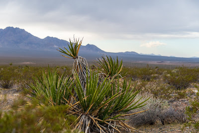
 |
| Photo of public lands in the DNWR along Alamo Road. Photo by Basin and Range Watch. |
The military is proposing sweeping changes for how our public lands are managed, and whether or not we can even access them. While the Nellis Test and Training Range serves a vital mission preparing the military for combat, DOD should ensure that its future plans for the range and wildlife refuge show more flexibility, innovation and precision. DOD should not expect us to readily hand over hundreds of square miles of additional public lands when it has not yet explained why the nearly 21,000 square miles of existing training ranges in the southwestern United States are insufficient.

Comments
Post a Comment